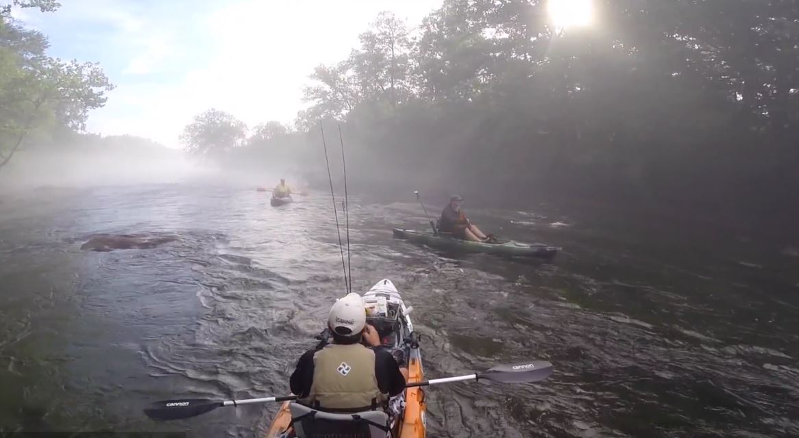
There is a stretch of river in Georgia where you can stand thigh-deep in 50 degree water on a 95 degree August afternoon, watch a heron work the far bank, and hear traffic on a six-lane road through the trees behind you. That contradiction is the whole story of the Chattahoochee tailwater, and it is the most underused outdoor asset in the Southeast.
The tailwater is the 48 miles of river below Buford Dam, running southwest from Lake Lanier through Forsyth, Gwinnett, Fulton, and Cobb counties until it reaches Atlanta’s western edge. Nearly all of it sits inside the Chattahoochee River National Recreation Area, a national park unit that most metro Atlanta residents have driven over a hundred times and never stopped at. It is one of the most visited sites in the entire National Park System, and it still feels empty on a Tuesday morning.
What makes it worth a trip rather than just a walk is the water itself. Buford Dam draws from deep in Lake Lanier and returns that water to the riverbed cold, year round, which has created a trout fishery at a latitude that has no business supporting one. The same cold water is why the river fogs on summer mornings, why the corridor runs ten degrees cooler than the parking lot, and why this is the best place in metro Atlanta to be outside in August.
It is also why the river demands more respect than it looks like it does. This is a dam-controlled river that changes level on a schedule most visitors do not know exists, which is why the single most useful thing in this guide is not a trail or a fishing spot. It is a link: chattahoocheetailwater.com and its Live Data Hub, which puts current river conditions, access points, and a plain-language fishing rating for the whole 48 miles on one screen. Full disclosure, I built it and I run it. More on how to use it below.
If you are building a wider Southeast river trip, our Nantahala Gorge guide covers the other great cold-water river within a half day’s drive.
Trip facts
Where The Chattahoochee River from Buford Dam downstream to Paces Ferry, roughly 48 miles, most of it inside the Chattahoochee River National Recreation Area in metro Atlanta. Best months October through May for fishing and hiking. June through August for paddling and tubing, when the cold water is the entire point. Getting there It runs through the north side of metro Atlanta. Access points sit off GA 20, Peachtree Parkway, Abbotts Bridge Road, Roswell Road, Johnson Ferry Road, and I-285 at Powers Ferry. Hartsfield-Jackson is about an hour south of the middle of the corridor in normal traffic. Good for Fly anglers, trail runners, paddlers, families who want a river afternoon without a hotel, anyone looking for shade and cold air in a Georgia summer. Skip if You want whitewater. Below the dam this is flat to mild moving water with a few shoals. The thrill here is the temperature and the trout, not the rapids.
Understanding the tailwater
A tailwater is the section of river immediately below a dam, and its character is set by where the dam pulls its water from.
Buford Dam draws from deep in Lake Lanier, well below the warm surface layer, and sends that water through the powerhouse into the riverbed. The Corps of Engineers puts the water coming out of the dam at an average of 44 to 58 degrees year round. In practical terms it stays cold enough, far enough downstream, to hold trout through a Georgia summer. Georgia DNR stocks the river, browns hold over and grow, and the result is a year-round trout fishery inside a metro area of more than six million people.
Two dams shape the corridor, not one. Buford Dam at the top is the Corps of Engineers hydropower facility, and it is the one that matters most. Morgan Falls Dam, further downstream near Sandy Springs, is a smaller Georgia Power dam that re-regulates flow before the river reaches the Palisades. Both release water, both change the river level, and both have their own schedule.
The park itself is a strange and useful thing: 48 river miles, 15 separate parcels of land, 13 of which you can drive to. There is no single park entrance and no single visitor experience. You pick a unit based on what you want to do that day. Island Ford in Sandy Springs holds the visitor center and the park headquarters.
One honest limitation. The riverbank is not all public. Much of the shoreline between park units is private property. The water is federally managed, but getting to it means using a park unit or a public ramp, not walking down someone’s back lawn.
Read this part: the generation schedule
The one thing that matters more than everything else here
When Buford Dam generates, the river below it rises fast. At Lower Pool Park immediately downstream of the dam, a release can raise the water by as much as 11 feet. Warning sirens sound between the dam and the GA 20 bridge, and water starts moving within minutes of the sirens stopping. The rise then travels downstream over hours, so a calm afternoon at a park unit fifteen miles below the dam can turn into a very different river without any warning you can see or hear.
Generation usually happens on weekday afternoons, but unscheduled releases happen in the morning and on weekends, particularly when downstream water demand is high or after heavy rain. Notice on those can be minutes rather than hours. Before you get in, check the schedule: the Buford Dam release line at 770-945-1466 or toll free 1-855-DAM-FLOW, Morgan Falls Dam at 404-329-1455, AM 1610 near the dam for current discharge information, the Corps of Engineers hydropower generating schedule online for the day’s release times and amounts, and the park’s downstream flow rate charts, which give you the travel time for that rise to reach your specific access point.
Full disclosure, I built and run chattahoocheetailwater.com, a live dashboard for this river that pulls current conditions, access points, and a fishing rating into one page. Use it for planning. For a go or no-go safety call, the Corps of Engineers generation schedule is the authoritative source, and it is the one to check last before you leave the truck.
Two more things. A Coast Guard approved personal flotation device must be worn on designated segments of the river, including the stretch from the dam down to the GA 20 bridge, so check the current park rules for the segment you are using. And the water that makes this river special is the same water that makes it dangerous: at 44 to 58 degrees, exhaustion or unconsciousness can set in within 30 to 60 minutes of immersion. Waders and a wading belt are not optional gear here in cold months.
The Live Data Hub, and why to use it
Planning a day on this river the hard way means opening four things at once: the Corps generation schedule, a USGS gauge page, a weather app, and a map to work out which access point sits where the flow will actually be good. None of those four talk to each other. None of them answer the question you actually have, which is whether today is worth the drive and where on 48 miles of river you should point the truck.
That is the problem chattahoocheetailwater.com was built to solve, and it is why I built it. It covers the full tailwater from Buford Dam to Paces Ferry as one system rather than as a scattered set of park units, and the part worth bookmarking is the Live Data Hub.
What the Hub puts in one place. Real-time water conditions for the tailwater, read as conditions rather than as a raw gauge chart you have to interpret. A fishing rating that turns those numbers into a plain answer about whether today is a good day to fish. Points of interest mapped along the corridor: fishing water, kayak and boat launches, tubing put-ins and takeouts. And it covers the whole river, not one gauge station or one park unit, which is the thing every other source gets wrong about this stretch.
Why that matters more here than on most rivers. The Chattahoochee tailwater is not one river. It is four or five different rivers depending on where you stand and what the dams are doing, and the level that makes Abbotts Bridge perfect can make the Palisades a slog. Locals eventually build that model in their heads over a decade of Saturdays. Nobody visiting for a weekend has that. The Hub compresses the learning curve from years to about ninety seconds.
If you are traveling in, use it before you book anything. Anglers driving down from Tennessee or the Carolinas, families deciding whether Saturday is a float day, paddlers picking a put-in and takeout pair for a two-car shuttle: check the Hub first, then plan the day around what it tells you rather than around what the calendar says. A weekend on this river planned blind is a coin flip. Planned against current conditions, it is one of the best outdoor days in the Southeast.
The division of labor. Use the Hub for planning, conditions, and picking your spot. Use the Corps of Engineers generation schedule for the go or no-go safety call, because that is the authoritative source and it is the one to check last before you leave the truck. Those two together are the whole prep routine.
When to go
The river does not really have an off-season. What changes is what you can comfortably do in it.
| Season | What it feels like | Crowds | Best for |
|---|---|---|---|
| March to May | Warm air, cold water, everything green, heavy generation days | Moderate on weekends | Fishing, trail running, the best all-around window |
| June to August | Cold river under brutal heat, fog on early mornings | Peak on the tubing and Palisades stretches | Tubing, paddling, dawn fishing, escaping the heat |
| September to October | Cooling air, low crowds, good color late | Light on weekdays | Hiking, photography, the quietest good fishing |
| November to February | Cold air over cold water, bare trees, long sight lines | Very light | Serious anglers, empty trails, wildlife |
Fishing the Hooch
This is one of the southernmost year-round trout fisheries in the country, and it fishes very differently depending on where you stand in the 48 miles.
The upper tailwater, from the dam down through the Settles Bridge and Abbotts Bridge stretches, runs coldest and holds trout most reliably. This is the section that fishes like a mountain river that got lost in the suburbs.
The middle section, through Medlock Bridge, Jones Bridge, and Island Ford, is the workhorse: good access, good wading at low flow, plenty of water to cover, and the most convenient parking for anyone in the northern suburbs.
The lower river, below Morgan Falls through the Palisades, warms more in summer and mixes trout with warmwater species. Shoals here fish well and paddle well.
Whichever section you pick, check the Live Data Hub fishing rating and current conditions the morning of. On a tailwater the flow is the variable that decides the day, and it changes faster than any report you read the night before.
Practical notes. You need a Georgia fishing license plus a trout license, and regulations vary by section and change, so check the current Georgia DNR rules before you go rather than trusting a forum post. Flows drive everything: low water means wading, generation means the fish move and you should not be standing where you were an hour ago. Cold water means waders most of the year and a wading staff more often than people admit.
One correction worth making, because it circulates locally: the Vickery Creek area at the Roswell mill is a genuinely good place to walk, see the dam and the mill ruins, and take photographs. It is not a trout fishing destination. Go there for the history and the trail, and fish the river itself.
Paddling, tubing, and the water in summer
Shooting the Hooch is a metro Atlanta institution, and the reason it works is thermodynamic. On a 95 degree Saturday, a river running in the 50s and 60s is the best air conditioning in the state.
Outfitters run tube and raft rentals with shuttles on the popular summer stretches around Powers Island and Johnson Ferry, which is the classic float. If you have your own boat, the corridor has ramps and canoe launches at multiple park units, and a full day trip between units is easy to arrange with two cars.
For a self-supported float, the launches, put-ins, and takeouts along the corridor are mapped on the tailwater Hub, which is the fastest way to pair two access points into a trip that fits the afternoon you actually have.
Fair warning on temperature in the other direction. This is not warm water. In May and September, a long float with a stiff breeze will get cold faster than people expect. Bring a dry layer and keep it in a dry bag. And check generation before any float, every time. A tube trip that started in ankle-deep shoals is a different trip an hour into a release.
Trails, ruins, and the rest of the corridor
The river is only half the park. The trail system runs to dozens of miles across the units, and several are worth a trip on their own.
Cochran Shoals is the flat, wide, crushed-gravel loop where half of metro Atlanta runs and walks dogs. Easy, busy, and genuinely pleasant.
Sope Creek, connected to Cochran Shoals, holds the ruins of the Marietta Paper Mill on a creek that drops through boulders. It is the best short hike in the corridor and it does not feel like Atlanta.
East Palisades has the bluff overlooks and the bamboo forest, which is exactly what it sounds like and is worth the walk.
Island Ford has the visitor center, big rock outcrops on the water, and easy riverside trail. Start here if you have never been.
Vickery Creek in Roswell has the mill ruins, the covered bridge, and the dam overlook, and it connects to the Roswell riverside parks.
Bowmans Island at the top end sits closest to the dam and gives you the coldest water and the emptiest trails.
The units, north to south. Bowmans Island, Settles Bridge, McGinnis Ferry, Abbotts Bridge, Medlock Bridge, Jones Bridge, Holcomb Bridge, Island Ford, Vickery Creek, Gold Branch, Johnson Ferry, Cochran Shoals with Sope Creek and Powers Island, the East and West Palisades, and Paces Mill at the downstream end. Learning that order is the single most useful thing you can do as a local, because it turns a vague 48-mile corridor into a list of specific places with specific personalities. Confirm the current unit list and any closures on the park website before you plan around one.
Wildlife is better than people expect for an urban corridor. Great blue herons and kingfishers work the shallows year round, deer are common at dawn in the upper units, and the shoals hold enough insect life to keep the trout interested. Beavers, otters, and the occasional bald eagle turn up. Bring binoculars on a slow morning and you will use them.
Park units are open sunrise to sunset. A parking fee applies at most of them, with a daily pass and a CRNRA annual pass available, and an America the Beautiful pass covers it. Buy in advance through Recreation.gov or at the Island Ford Visitor Center, and check current pricing rather than trusting an old sign. Leashed pets are welcome. Glass is not allowed on the river, so leave the bottles in the car.
A first-visit day plan
Morning. Check generation. Start at Island Ford, walk the riverside trail, and get a look at the water at a normal level so you know what a normal level looks like.
Midday. Drive down to Sope Creek and hike the mill ruins loop. Bring lunch and eat on the rocks.
Afternoon. Depending on the season, either float the Powers Island stretch or fish the upper river near Abbotts Bridge as the light goes long.
Evening. Dinner on the Roswell square or in Sandy Springs, both a short drive from the corridor.
That is one day. The better version is picking one unit and going back to it a dozen times until you know what it does at every flow.
How to use the Chattahoochee Tailwater Hub
The mistake people make with the Chattahoochee tailwater is treating it as scenery they drive past instead of a destination. It is a national park unit with a cold-water trout fishery, 48 miles of moving water, and a real trail system, sitting inside one of the largest metro areas in the country. There is no other river like it in the Southeast.
Start with the generation schedule and the Live Data Hub. Pick a unit that matches what you want that day. Dress for water in the 50s regardless of the forecast. Then go on a weekday if you possibly can, because on a Tuesday in October you will have a stretch of national park river to yourself twenty minutes from an interstate.
Big Terrapin. Slow down, look closer, go anyway.