A Complete RV Guide Along the Mississippi River from Minnesota to the Gulf
Minnesota • Wisconsin • Iowa • Illinois • Missouri • Kentucky • Tennessee • Arkansas • Mississippi • Louisiana
2,552 Miles • Ten States • River Bluffs • Music History • Civil War Ground • The American Delta
Introduction: Following the Father of Waters
The Mississippi River is 2,552 miles long from its source at Lake Itasca in northern Minnesota to its mouth in the Gulf of Mexico south of New Orleans. It drains 41 percent of the contiguous United States — the water that falls on land from western Montana to western Pennsylvania eventually finds the Mississippi and follows it south. It has been called the Father of Waters, Old Man River, the Big Muddy, and the body of water that Mark Twain understood better than any writer has understood a river before or since. It is the organizing spine of the American interior, the reason that New Orleans exists, the boundary on which the Civil War was partly decided, and the corridor along which blues music traveled from the Mississippi Delta to Chicago to become the foundation of most American popular music in the 20th century.
The Great River Road is the designated scenic byway system that follows the Mississippi from Minnesota’s Lake Itasca to the Gulf of Mexico. It is not a single continuous road in the way that Route 66 or the Pacific Coast Highway is a single road; it is a network of state and county roads, both on the Minnesota side and the Wisconsin side of the river in the north, weaving back and forth between states as the bridges and the road quality dictate, all marked with the familiar green pilot’s wheel sign that indicates you are on the designated route. It passes through ten states, hundreds of river towns, and a landscape that shifts remarkably from the cold northern forests and glacially shaped bluffs of Minnesota and Wisconsin to the Iowa and Illinois cornfields and the dramatic limestone bluffs of Missouri and the lower Midwest, through the Civil War battlefields and music towns of Tennessee and Mississippi, and finally into the broad, slow, subtropical delta country of Louisiana where the river loses its banks entirely and disperses into the Gulf.
For the RV traveler, the Great River Road is one of the most historically and culturally dense road trips in North America. No other route in this guide series passes through as much living American history — the fur trade outposts, the steamboat towns, the Civil War siege works, the cotton plantations, the Blues Highway, the birthplace of jazz. The pace the river suggests is the right pace: slow, attentive, and willing to be stopped by a historical marker or a river overlook or the smell of a barbecue smoker at a roadside joint in a way that the interstate discourages. The river rewards this approach. It has been here a long time and it is not in a hurry, and neither should you be.
Route Snapshot 2,552 miles from Lake Itasca, Minnesota, to Venice, Louisiana. Ten states: Minnesota, Wisconsin, Iowa, Illinois, Missouri, Kentucky, Tennessee, Arkansas, Mississippi, and Louisiana. Plan 21 to 28 days for the full route, or select the Upper Mississippi (Minnesota to St. Louis) or Lower Mississippi and Delta (St. Louis to New Orleans) as a two-week section.
Planning Your Great River Road RV Journey
Running the Full Route vs. Sections
The Great River Road’s 2,552 miles and ten states represent a commitment that most RV travelers will want to approach in one of three ways. The full route from Lake Itasca to the Gulf runs comfortably in 21 to 28 days at a pace that allows time for the towns, the history, and the river overlooks that justify the journey. This is the recommended approach for those with the time, as the river’s character changes so dramatically from north to south that abbreviating either end significantly reduces the range of experience.
The Upper Mississippi section — Lake Itasca to St. Louis — covers approximately 1,100 road miles and the most dramatic river bluff scenery of the route. It passes through the Driftless Area’s limestone bluffs, the Quad Cities’ industrial river history, and Hannibal, Missouri, where Mark Twain grew up. This section is best in May through October and takes 10 to 14 days.
The Lower Mississippi and Delta section — St. Louis to New Orleans via the Blues Highway, Memphis, Clarksdale, Natchez, and Baton Rouge — covers approximately 1,300 road miles through the most historically and musically significant terrain of the route. This section connects the Civil War’s western theater, the birthplace of the blues, the Antebellum South’s plantation country, and the Creole culture of Louisiana. It takes 10 to 14 days and is best in October through April when the Deep South heat is manageable.
The middle section — roughly St. Louis through Memphis — is the most flexible connector, passing through Missouri, Kentucky, Tennessee, and Arkansas in a corridor of river towns, Civil War sites, and early American settlement history that is underappreciated relative to the sections on either side of it.
Pro Tip Driving both sides of the river makes the journey three-dimensional. In the Driftless Area of Wisconsin and Minnesota, the Wisconsin side (WI-35) provides the finest bluff views while the Minnesota side (US-61) provides the better towns. Cross at the bridges and drive both banks on different days for the full Upper Mississippi experience.
Best Time to Travel
The full Great River Road spans ten states and a climate range from the subarctic winters of northern Minnesota to the subtropical summers of Louisiana, which means no single ideal travel window applies to the entire route. The practical calculation involves two separate seasons.
For the Upper Mississippi segment (Minnesota through Iowa and Illinois), May through early October is the travel window. The Minnesota and Wisconsin river bluffs are at their finest in May (wildflowers and spring green) and October (fall foliage), when the maple, oak, and hickory forests color the bluffs above the river. Summer is warm and humid but manageable. The Upper Mississippi River Wildlife and Fish Refuge’s backwater lakes are most productive for wildlife viewing in late spring and early fall.
For the Lower Mississippi and Delta segment (Missouri south through Louisiana), October through April is the preferred window. The Delta’s summer heat and humidity are serious: temperatures in the Mississippi Delta in July routinely reach 100°F with 90 percent humidity. New Orleans in summer is possible if you keep your RV’s AC running, but the bayou and plantation country south of Natchez is genuinely uncomfortable for outdoor activity from June through September. The cotton and soybean fields of the Delta in October and November have their own austere beauty; the Delta in March, when the roadside wildflowers are beginning and the weather is cool and clear, is the finest.
A full route journey that departs Lake Itasca in mid-September and arrives in New Orleans by mid-October threads the needle: fall foliage on the Upper Mississippi bluffs, cooling temperatures in the Delta, and a New Orleans arrival in October when the weather is finest and the cultural calendar is richest.
Understanding the Great River Road Sign System
The Great River Road is marked by the green pilot’s wheel sign, a circular emblem adopted in 1938 that represents the steamboat pilot wheel that guided commerce on the river for a century. The sign appears on highways, county roads, and city streets throughout the ten-state route, indicating the designated scenic byway. It is not always on the most direct road; in many sections it deliberately routes travelers through river towns and overlooks rather than along the faster highway alternatives.
Each of the ten states maintains its own Great River Road section with varying degrees of signage consistency. Minnesota and Wisconsin have the most consistent signage; the Mississippi and Louisiana sections are less reliably signed in rural areas. Download the Great River Road Network’s official state-by-state maps from experiencemississippiriver.com before departure and carry the print versions as backup. The Mississippi River Trail (a parallel bicycle route) shares some Great River Road segments and the maps show both.
RV Considerations
The Great River Road is one of the most RV-accessible long-distance routes in the country. The roads are generally paved, the campground network is well-developed along both banks from Minnesota to Louisiana, and the flat-to-gently-rolling terrain requires none of the mountain pass caution of the western routes in this series. The specific considerations that deserve attention are primarily navigational.
- Ferry crossings: Several points on the Great River Road route are served by free river ferries rather than bridges. The Cassville Ferry in Wisconsin, the Ste. Genevieve ferry in Missouri, and several other Mississippi crossings accommodate vehicles including most RVs. Check size and weight restrictions at specific ferry landings before attempting to board; some ferries have vehicle height restrictions of 13 to 14 feet or weight limits incompatible with large Class A motorhomes.
- Bridge routing: The Mississippi has 130 bridges from headwaters to Gulf. The Great River Road route uses many of them; some are older structures with weight and height restrictions. Check your state’s Department of Transportation for current bridge restrictions on designated route segments.
- River road flooding: The Mississippi River’s floodplain is exactly that — land that floods regularly. Roads along the lower river and in the Delta can be inundated during high water events, typically spring flooding in March through June. Check current river levels at the USGS National Water Information System (waterdata.usgs.gov) for your travel corridor before driving low-lying river road sections.
- Fuel in rural Delta country: The Mississippi Delta counties of Mississippi and Arkansas are among the most rural and economically challenged regions in the United States. Gas stations can be 30 to 40 miles apart on the Delta’s back roads, and diesel is not always available at stations that carry regular gasoline. Fill whenever the tank drops below half in the Delta.
- Campgrounds in the Deep South: Full-hookup RV parks are available in all Mississippi River cities but can be sparse in the rural segments of the route, particularly in the Mississippi Delta between Greenville and Natchez. The Corps of Engineers campgrounds along the river provide affordable alternatives with river views; KOAs in the larger towns fill the gap.
The River as Living Character
The Mississippi River is not passive scenery. It is a working river of enormous energy and consequence — the primary commercial waterway of the American interior, carrying more cargo annually than any other waterway in the country. Barges and towboats push up to 15 barge tows simultaneously — each barge carrying as much as 60 semi-trucks — in massive assemblies that move at walking speed through the river’s curves. Lock and dam systems on the upper river lift and lower these assemblies in a process of industrial poetry that takes 45 minutes and is worth watching in full from the observation decks at locks throughout Minnesota, Wisconsin, Iowa, and Illinois.
The river’s character changes dramatically across its length. In northern Minnesota at Itasca, you can wade across the Mississippi at its source — a stream 20 feet wide and ankle deep. By the time it reaches Minneapolis it is a river of substance. At St. Louis, the Missouri River has joined it and it is a genuinely large, powerful, turbid body of water. In the Delta of Louisiana, it has become something immense and elemental — a mile wide, 200 feet deep, carrying half a million cubic feet of water per second to the Gulf, indifferent to the levees and infrastructure that attempt to contain it.
Minnesota: The Headwaters and the Twin Cities
Lake Itasca and the Mississippi Headwaters
Itasca State Park, in the lake country of northwestern Minnesota, contains the headwaters of the Mississippi River — the spot where Lake Itasca’s overflow becomes the trickle that will, 2,552 miles later, pour into the Gulf of Mexico. The headwaters crossing — a dozen stepping stones across a 20-foot-wide stream — is one of the most anticlimactic-looking and most emotionally resonant experiences on the entire route. You are standing at the beginning of the river that organized the American continent, and the water moving quietly over your feet will reach New Orleans in approximately 90 days.
Itasca State Park is Minnesota’s oldest and largest state park, established in 1891. Beyond the headwaters, the park preserves old-growth red pine forest of extraordinary beauty — trees 300 to 500 years old in stands that feel genuinely primeval in a state where the original white pine forest was largely logged out in the late 19th century. The Wilderness Drive, a 16-mile auto tour through the old-growth, is the finest single drive in Minnesota’s state park system. The park campground accommodates RVs and fills on summer weekends; book through Minnesota’s reservation system in advance.
Overlook Preacher’s Grove in Itasca State Park contains the finest accessible stand of old-growth red pine in Minnesota — trees 300 years old and 100 feet tall in a grove that produces a quality of light, silence, and scale that rewires the traveler’s sense of the appropriate pace for the journey ahead. Walk it before driving south.
The Upper Mississippi River Valley: Brainerd to the Twin Cities
US-10 and MN-371 south from Itasca carry the route toward the Twin Cities through the lake country of central Minnesota — a landscape of glacially carved lakes, birch forest, and small fishing resort towns that has defined the Minnesota summer vacation for generations. Brainerd, the commercial hub of Minnesota’s lake country, is the gateway to the Boundary Waters Canoe Area Wilderness to the northeast and the Paul Bunyan Trail bicycle route. The Crow Wing State Park near Brainerd preserves the confluence of the Crow Wing and Mississippi Rivers where a significant Ojibwe trading post operated from the 1820s.
Minneapolis and St. Paul, the Twin Cities, anchor the route’s northern urban segment and reward at least two days of exploration. Minneapolis is one of the finest mid-sized cities in the United States — a city of exceptional parks, a thriving independent music scene, a nationally significant arts infrastructure, and the Mississippi River gorge running through its urban core in a canyon of sedimentary bluffs that most visitors do not expect. The Mill District, where Minneapolis’s flour milling industry once produced 20 percent of the nation’s flour, has been brilliantly redeveloped with the Mill City Museum and the Guthrie Theater’s cantilevered Endless Bridge overlook providing the finest urban Mississippi views in the United States.
The Walker Art Center and Minneapolis Sculpture Garden, the Weisman Art Museum at the University of Minnesota (a Frank Gehry building of considerable exuberance above the river gorge), and the Minneapolis Institute of Art — which holds an encyclopedic collection of extraordinary range — make Minneapolis one of the finest mid-sized museum cities in the country. The Minnehaha Falls in Minnehaha Park, which Henry Wadsworth Longfellow celebrated in The Song of Hiawatha without ever visiting Minnesota, are a 53-foot waterfall in an urban park of exceptional quality.
St. Paul, across the river, has a more European urban character than Minneapolis — a city organized around cathedral squares and Victorian commercial architecture rather than Modernist planning. Summit Avenue, a 4.5-mile boulevard of Victorian and Edwardian mansions, is the finest residential streetscape in Minnesota and the street where F. Scott Fitzgerald lived and where he wrote This Side of Paradise. The Minnesota History Center on the Capitol Mall is the finest state history museum in the Midwest, with a permanent exhibition on the Dakota people and the settlement of Minnesota of genuine depth and honesty.
Music Stop First Avenue in Minneapolis, the nightclub where Prince recorded the live album he filmed as Purple Rain, is one of the most significant performance venues in American popular music history. The club continues to operate on 7th Street North in downtown Minneapolis with a booking calendar that ranges from emerging artists to national acts. The exterior’s constellation of stars, each bearing the name of a performer who has sold out the room, is a wall of American music history.
Wisconsin: The Driftless Area and the Great River Bluffs
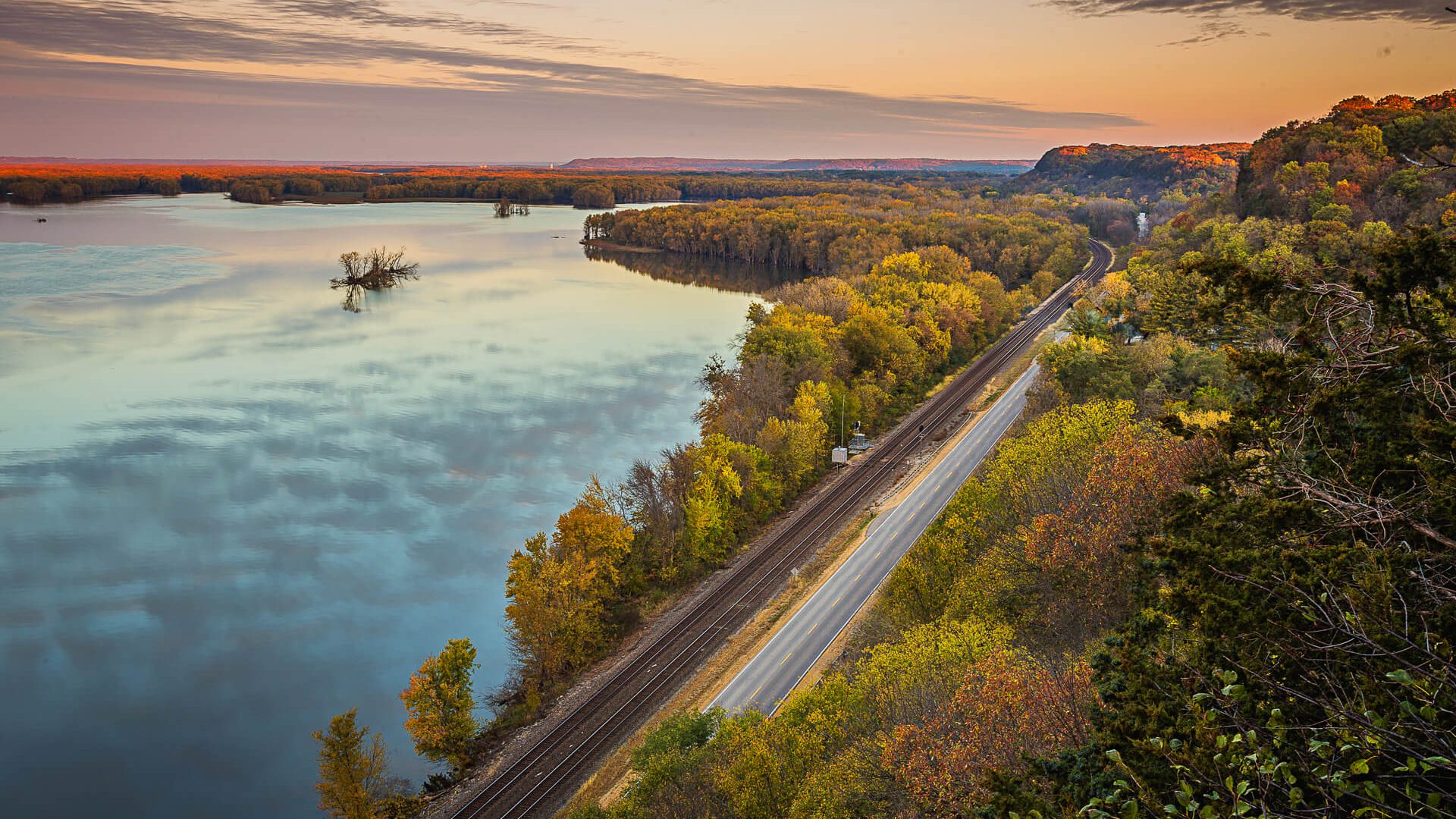
The Great River Road enters Wisconsin at the crossing of the St. Croix River and follows WI-35 south through one of the most scenically extraordinary landscapes on the entire route: the Driftless Area. The Driftless Area is a roughly 24,000-square-mile region of southern Wisconsin, southeastern Minnesota, northeastern Iowa, and a fragment of Illinois that was never covered by the glaciers that flattened most of the surrounding terrain. The result is a landscape of steep ridges, deep river valleys, spring-fed streams, and limestone bluffs that towers 400 to 600 feet above the Mississippi River — the most dramatic river bluff scenery in the Upper Midwest.
The Mississippi Palisades and the Great River Road bluffs between Prescott and Prairie du Chien are the most dramatic section of the Upper Mississippi River. The river here winds through a valley between high limestone bluffs that the glaciers’ absence left ungraded and unsmoothed. The towns are river towns of 19th-century character: Alma, Pepin, Stockholm, Maiden Rock, Bay City, and the larger cities of La Crosse and Prairie du Chien, each occupying the narrow terrace between the bluff face and the river edge.
WI-35: The Great River Road in Wisconsin
Wisconsin Highway 35 through the Driftless Area is the finest river road in the upper Mississippi corridor. The highway runs along the river’s eastern bank for most of its Wisconsin length, with the bluffs rising 400 to 500 feet above the road and the river and its backwater lakes and islands spreading west toward the Minnesota shore. The Great River Road National Scenic Byway designation is well-earned here; this is the section that justifies the route’s claim to scenic status among the finest in the country.
Overlook Buena Vista Park overlooking Alma, Wisconsin, provides the finest single overlook of the Upper Mississippi. The view north and south from the bluff top, 500 feet above the river, takes in the full breadth of the Mississippi valley — the river braided through its islands, the backwater lakes silver in the afternoon light, the Minnesota bluffs rising on the far side — in a panorama that is one of the finest river views in North America. The drive to the overlook on a county road from Alma is straightforward for most RVs.
Pepin, Wisconsin, is the birthplace of Laura Ingalls Wilder, the author whose Little House on the Prairie series defined the experience of frontier life for generations of American readers. The Little House Wayside, a reconstruction of the Ingalls family cabin six miles north of Pepin, marks the site where Wilder was born in 1867. The Pepin Historical Museum provides context for Wilder’s early life and the 19th-century settlement of the upper river valley. The town itself, a classic Wisconsin river community on Lake Pepin, has a fine waterfront and the Harbor View Café — one of the finest locally sourced restaurants in western Wisconsin.
La Crosse is the largest city on the Wisconsin Great River Road and the most significant river town between the Twin Cities and Dubuque. The city occupies a wide terrace between the bluffs and the river at the confluence of the Black, La Crosse, and Mississippi Rivers, and its 19th-century commercial architecture along Pearl and Main Streets preserves a downtown of genuine Victorian character. The Grandad Bluff above the city, accessible by a steep park road, provides a 1,200-foot panorama of the Mississippi valley and the Iowa bluffs across the river that is the finest single urban overlook on the route.
Prairie du Chien, at the mouth of the Wisconsin River where it joins the Mississippi, is the second-oldest city in Wisconsin (after Green Bay) and a significant point on the fur trade network that connected the Great Lakes with the Mississippi watershed for two centuries. Villa Louis, a Victorian mansion built by fur trade magnate Hercules Dousman on the island where Fort Crawford once stood, is the finest intact Victorian river estate in the upper Midwest and presents the fur trade era’s material culture with exceptional depth.
Iowa: The River Bluffs and Effigy Mounds
Iowa’s Great River Road follows the Mississippi’s western bank from the Minnesota border south to the Quad Cities, passing through a landscape of blufftop farms, river towns, and the Upper Mississippi River National Wildlife and Fish Refuge — 240,000 acres of backwater lakes, islands, and wetlands that extend along both sides of the river for 261 miles from Wabasha, Minnesota, to Rock Island, Illinois. The refuge is one of the most productive freshwater wildlife areas in the country, supporting 300 bird species, 113 species of fish, and abundant beaver, otter, and white-tailed deer along its backwater channels.
Effigy Mounds National Monument
Effigy Mounds National Monument, near Marquette, Iowa, preserves 206 prehistoric earthen mounds built by Indigenous peoples of the Late Woodland period between 300 BCE and 1300 CE on the high bluffs above the Mississippi. Many are constructed in the shapes of bears and birds — the effigies that give the monument its name — in a tradition of mound building that represents one of the most distinctive cultural practices of the pre-Columbian Mississippi valley. The Fire Point Trail climbs to the bluff top and passes through the Great Bear Mounds group, where 10 bear effigies up to 137 feet long march in procession toward the river edge below, visible from the bluff in their full pattern only when snow covers the surrounding ground.
The monument visitor center’s interpretation of the Late Woodland mound-building tradition and its relationship to the Oneota and Ho-Chunk peoples who inhabit the region today is among the most respectful and historically nuanced of any National Park Service site on the route. The bluff views from the monument’s North Unit overlooks, with the Mississippi and its islands spread below and the Wisconsin bluffs across, are among the finest on the Iowa side of the river.
Yellow River State Forest Immediately west of Effigy Mounds, the Yellow River State Forest’s Paint Creek Unit preserves 9,000 acres of Driftless Area woodland — the finest remaining old-growth forest in Iowa, with forest-floor wildflowers in May and October color in the ridgeline hardwoods. The Paint Creek Campground, accessible by an improved road, is the finest dispersed camping in Iowa’s Driftless zone.
Dubuque: The Architectural River City
Dubuque is the oldest city in Iowa (incorporated 1833) and the most architecturally distinguished city on the Iowa Great River Road — a city of Victorian commercial buildings, bluffside neighborhoods connected to the riverfront by the Fenelon Place Elevator (the shortest and steepest scenic railway in the world, climbing 189 feet in 296 feet of track), and the National Mississippi River Museum and Aquarium, which is the finest single institution dedicated to the natural and cultural history of the Mississippi River anywhere on the route.
The Dubuque Arboretum and Botanical Gardens provides 52 acres of horticultural display above the city. The Mines of Spain State Recreation Area, south of Dubuque on the river, preserves the lead mining landscape that drew the region’s first European settlers and provides blufftop trails above the Mississippi with the finest river views accessible on foot from the Iowa side in this segment.
Illinois: Galena and the Quad Cities
Galena: The Ulysses Grant Town
Galena, Illinois, sits in a valley of the Galena River eight miles east of the Mississippi — a detour well worth taking from the Great River Road. The town preserves more pre-Civil War commercial and residential architecture than any other community in Illinois, a consequence of the lead mining wealth that made it briefly the most prosperous city in the state in the 1840s and 1850s and the subsequent economic stagnation that followed, which prevented the 20th-century redevelopment that destroyed most comparable American towns. Main Street’s two-block commercial corridor of 19th-century brick storefronts, intact from sidewalk to cornice, is one of the most complete 19th-century commercial streetscapes in the Midwest.
Ulysses S. Grant lived in Galena before the Civil War and returned to a hero’s welcome when the war ended. The Ulysses S. Grant Home State Historic Site, the Italianate house given to Grant by the citizens of Galena upon his return in 1865, preserves the furnishings and context of the town’s relationship with its most famous resident with genuine historical depth. The Grant Museum adjacent to the site provides substantial context for Grant’s life, military career, and presidency.
Quad Cities and the Rock Island Arsenal
The Quad Cities — Rock Island and Moline on the Illinois side, Davenport and Bettendorf on the Iowa side — constitute the metropolitan center of the Upper Mississippi’s industrial corridor, where the river’s energy powered mills and manufacturing from the 1840s forward. Rock Island Arsenal, on an island in the Mississippi between Rock Island and Davenport, has been continuously in operation since 1862 and is the largest government-owned weapons manufacturing arsenal in the United States. The Confederate cemetery on the island contains 1,964 graves of Confederate prisoners who died during their confinement at Rock Island Prison during the Civil War — a sobering counterpoint to the arsenal’s manufacturing functions.
Davenport’s River Music Experience, housed in a restored riverside building at the foot of the Centennial Bridge, is the finest music museum on the Upper Mississippi and the primary institution dedicated to the musical heritage of the river towns — covering the origins of jazz and blues that flowed up the river from New Orleans and the ragtime tradition that Scott Joplin developed in the Missouri river towns south of here.
Hannibal and Mark Twain Country, Missouri
Hannibal, Missouri, is the town where Samuel Langhorne Clemens grew up and became Mark Twain — where he absorbed the river, the town characters, the vernacular speech, and the moral complexity of pre-Civil War Missouri that he processed into The Adventures of Tom Sawyer, Adventures of Huckleberry Finn, and Life on the Mississippi. It is one of the few American literary pilgrimage sites where the landscape and the built environment genuinely connect to the work: the wide Mississippi at Hannibal, visible from the bluffs that Twain climbed as a boy, is recognizably the same river he described, and the town’s Main Street preserves the antebellum building stock in a way that makes the imaginative reconstruction of 19th-century Hannibal easier than at most historic sites.
The Mark Twain Boyhood Home and Museum complex encompasses the two-room house where Clemens lived from ages 4 to 17, the adjacent house of Laura Hawkins (the model for Becky Thatcher), the law offices of Twain’s father, and a substantial museum presenting the development of Clemens’s literary career with first editions, correspondence, and interpretive depth appropriate to a writer of Twain’s significance. The interpretive materials do not shrink from the moral complexities of Twain’s work — the depiction of Jim in Huckleberry Finn and the critique of slavery that the novel embodies — and the result is one of the most honest literary sites in American public history.
Cardiff Hill and the River View The limestone bluff above Hannibal that Twain climbed as a boy and called Cardiff Hill in Tom Sawyer has a Confederate memorial at its summit and a view down the Mississippi that is, despite the changes two centuries have brought to the landscape, still recognizable as the view Twain described. The climb is short and the view is worth it. In the morning light, with a towboat pushing north through the main channel and the Illinois bottomlands stretching east below you, you understand something about why a boy who grew up here became a writer obsessed with the river.
New London, Clarksville, and Elsberry downstream from Hannibal are the river towns that most closely preserve the pre-Civil War Mississippi valley character — small communities of brick commercial buildings above the river bluff, with the ferry landings and steamboat wharves that once defined them now represented only by the Corps of Engineers lock and dam structures and the occasional barge terminal. The drive along MO-79 between Hannibal and St. Louis is one of the finest river road segments in Missouri, staying on the bluffs above the river through a succession of small towns and overlooks.
St. Louis: Gateway to the South
St. Louis is the Great River Road’s pivot point — the city where the Missouri River joins the Mississippi from the west, where the river turns definitively southward, where the cultural character of the route shifts from the Midwestern river towns of the Upper Mississippi to the Southern river culture of the lower valley. The Gateway Arch, Eero Saarinen’s 630-foot stainless steel parabola above the Jefferson National Expansion Memorial on the riverfront, is the most recognized structure on the Mississippi River and one of the finest pieces of public architecture in the United States — simultaneously a monument to Westward expansion, a functional tram ride to a spectacular river overlook, and an object of such formal purity that it rewards as much time as you give it.
The Museum of Westward Expansion beneath the Gateway Arch presents the Lewis and Clark expedition, the Oregon and Santa Fe Trails, the Native American experience of westward expansion, and the role of St. Louis as the logistical hub of American continental movement with genuine historical ambition. The Courthouse adjacent to the arch was the site of Dred Scott v. Sandford’s original 1846 trial — the case whose Supreme Court outcome accelerated the Civil War’s arrival. Both the arch and the courthouse are free as part of the National Park Service site.
Forest Park, the 1,300-acre public park where the 1904 World’s Fair was held, contains the St. Louis Art Museum (one of the finest encyclopedic art museums in the country, free admission), the St. Louis Zoo (consistently rated among the top five in the United States, also free), the St. Louis Science Center, and the Missouri History Museum — all free, all outstanding, and all within a park of such scale and quality that a full day here is entirely justified. The park’s location at the end of the grand Central West End boulevard makes it the finest urban park on the Great River Road.
The Cherokee Street Antique District and the Soulard Market neighborhood south of downtown provide the most authentic experience of St. Louis’s non-tourist commercial culture. The Soulard Market, a public market operating since 1779, is the oldest continually operating public market west of the Mississippi. The City Museum, housed in a former shoe factory in downtown St. Louis, is simultaneously one of the most extraordinary art installations, playgrounds, and architectural re-imaginations in the country — a 10-story building entirely sheathed in reclaimed building materials, with climbing structures that extend to the roof and a ferris wheel on top. It is indescribable and essential.
Music Stop The blues tradition in St. Louis — the East St. Louis side especially — produced Ike Turner, Chuck Berry, and a R&B sound that bridged Delta blues and rock and roll. The National Blues Museum on Market Street presents the full arc of blues music from the Delta to Chicago and St. Louis with interpretive quality that rivals the Delta Blues Museum in Clarksdale. The BB’s Jazz, Blues and Soups club on Leffingwell has been one of the finest live blues venues in the Midwest for decades.
The Confluence Country: Cairo, Kentucky, and Tennessee
Cairo and the Ohio River Confluence
Cairo, Illinois, sits at the confluence of the Ohio and Mississippi Rivers — the point where the Ohio’s clear blue water meets the Mississippi’s brown current in a visible line that persists for miles downstream. This confluence is one of the great geographical facts of the American interior: it is here that the entire watershed of the Ohio River — Pennsylvania, Ohio, Indiana, Kentucky, West Virginia — joins the Mississippi in a doubling of the river’s volume that makes it something immensely more powerful below Cairo than above it. The Confluence Point State Historic Site on the Missouri side provides the finest view of the joining.
Cairo itself is one of the most haunting places on the Great River Road — a city whose population declined from 15,000 in 1920 to fewer than 2,000 today following decades of economic collapse, racial tension, and the departure of its commercial base. The historic Custom House (a Victorian federal building of considerable quality), the Magnolia Manor bed-and-breakfast (an 1872 Italianate mansion), and the river views from the levee top at the confluence are the primary attractions in a town that feels like it is in the process of being returned to the bottomland forest from which it was carved. The weight of the history here is palpable and worth the stop.
New Madrid and the Earthquake Zone
New Madrid, Missouri, gives its name to the New Madrid Seismic Zone — the most active earthquake zone in the continental United States east of the Rocky Mountains. The New Madrid earthquakes of 1811 to 1812, a series of three massive events with estimated magnitudes of 7.5 to 8.0, were the most powerful earthquakes in recorded North American history. They rang church bells in Boston, were felt in Washington DC, and caused the Mississippi River to temporarily flow backward in the affected reaches. The New Madrid Historical Museum presents the earthquake history alongside the town’s antebellum and Civil War history with appropriate gravity.
Memphis, Tennessee: Where the Blues Met the City
Memphis is the most musically significant city on the Mississippi River and one of the most significant in American cultural history. It is the city where Delta blues musicians arrived from the Mississippi Delta — from Clarksdale, Greenville, and the plantation towns of the Yazoo-Mississippi Delta — and found an audience, a recording industry, and the cultural infrastructure that allowed their music to reach the world. It is the city where W.C. Handy formalized the blues as a composed music. Where Sam Phillips recorded Howlin’ Wolf, Ike Turner, and Elvis Presley at Sun Studio. Where Al Green recorded at Stax. Where Isaac Hayes and Booker T. and the MGs defined soul music. Where Martin Luther King Jr. was assassinated at the Lorraine Motel in 1968.
Beale Street, the historic entertainment district where W.C. Handy performed and where the blues found its first sustained commercial venue, is today a three-block pedestrian entertainment zone of bars, live music venues, and tourist restaurants that is simultaneously the most visited cultural site in Tennessee and a significant oversimplification of Memphis’s musical heritage. It is worth one evening. The real Memphis music history requires going deeper.
Music Stop Sun Studio at 706 Union Avenue is the most important single address in American popular music history. Sam Phillips recorded “Rocket 88” by Ike Turner and Jackie Brenston here in 1951, widely considered the first rock and roll record, and then B.B. King, Howlin’ Wolf, and Elvis Presley. The studio is still operational — recording sessions happen at night after the daytime tours. The studio itself is small, low-ceilinged, and exactly as it was in 1954. Standing where Elvis stood when he recorded “That’s All Right” produces a specific feeling that no amount of interpretive framing can manufacture.
The Stax Museum of American Soul Music on McLemore Avenue stands on the site of the former Stax Records studio — rebuilt as a museum after the original building was demolished in 1989 — and is the finest music museum in the American South. The collection includes Isaac Hayes’s gold-plated Cadillac, the original Stax recording studio (reconstructed with original equipment), and interpretive materials on the soul and R&B tradition that explain the music’s social and cultural context with the depth it deserves. The museum is in the South Memphis neighborhood; the surrounding community is actively engaged with the museum’s educational mission through the Stax Music Academy.
The National Civil Rights Museum at the Lorraine Motel, where Dr. King was shot on April 4, 1968, is one of the most important museum experiences in the country — a comprehensive presentation of the American civil rights movement from the antebellum period through the present day, organized around the Lorraine Motel’s role as a symbol of the movement’s cost. The rooms where King spent his final hours are preserved behind glass as he left them. The museum’s scope, from the slave trade to the March on Washington to the Poor People’s Campaign, requires four hours minimum and rewards every minute of it.
Graceland, Elvis Presley’s home on Elvis Presley Boulevard in Memphis, is one of the most visited private homes in the United States and the most significant pilgrimage site in American popular music. The house itself — a Colonial Revival mansion of modest scale by celebrity standards, decorated in the 1970s tastes that Elvis never updated — is preserved exactly as it was when he died in 1977, down to the mirrored ceiling and the shag carpet in the Jungle Room. The tour is designed for those who loved Elvis; if you did not, the experience of seeing 50,000 square feet of memorabilia, gold records, and sequined jumpsuits may convert you.
The Mississippi Delta: The Blues Highway
The Mississippi Delta is not a geographical delta. It is a 200-mile-long, 70-mile-wide alluvial floodplain between the Mississippi and Yazoo Rivers in the northwestern corner of Mississippi, one of the most fertile agricultural landscapes in the world and the birthplace of the blues. The Delta produced Robert Johnson, Son House, Charley Patton, Muddy Waters, Howlin’ Wolf, B.B. King, John Lee Hooker, and Bessie Smith. It produced the cotton economy that made it one of the wealthiest agricultural regions in America before the Civil War and one of the most persistently impoverished after it. It produced the food traditions — tamales, hot tamales specifically — that arrived with Mexican railroad workers in the early 20th century and became the Delta’s most specific culinary artifact. It produced a landscape of extraordinary flatness and a sky of extraordinary size that together create conditions in which the distance between the horizon and the imagination becomes very small.
US-61, the Blues Highway, runs the length of the Delta from Memphis south through Tunica, Clarksdale, Cleveland, Greenville, Leland, and Vicksburg. It is one of the most historically loaded highways in the United States — the road that the Delta’s sharecroppers traveled north during the Great Migration, carrying the blues to Chicago and Detroit and reshaping American music in the process. Driving it south from Memphis in the morning, with the flat cotton fields on both sides and the occasional town of a water tower and a grain elevator and a church, is to understand something about the specific quality of emptiness that the Delta’s landscape produces and why the music that came from it sounds the way it does.
Clarksdale: The Blues Crossroads
Clarksdale is the blues capital of the Mississippi Delta and the most significant destination on the Blues Highway. The Delta Blues Museum, housed in the restored 1918 Illinois Central freight depot, is the finest museum dedicated to Delta blues music, with instruments, photographs, and archival materials documenting the tradition from its pre-commercial origins through its influence on rock and roll. The museum’s collection includes a reconstructed portion of the sharecropper cabin where Muddy Waters was born on Stovall Plantation, the plantation’s original piano, and audio and video materials of genuine depth.
The crossroads of US-61 and US-49 at the edge of downtown Clarksdale marks the legendary location where Robert Johnson supposedly sold his soul to the devil at midnight in exchange for his guitar skills — a story that Johnson himself never confirmed, that appears to conflate several different intersections mentioned in Delta blues tradition, and that has nonetheless become one of American music mythology’s most productive stories. There is a sign. Photographs are taken. The musical truth is that Robert Johnson was a remarkable guitarist who died in 1938 at age 27 under circumstances that remain genuinely unclear.
Music Stop Ground Zero Blues Club in Clarksdale, co-owned by Morgan Freeman who is from Mississippi, occupies a former cotton warehouse with the original wood floors and a blues calendar that features live music most nights of the week. The Bluesberry Café on Delta Avenue and Rust Restaurant in the Alluvian Hotel provide the finest dining in the Delta. Red’s Lounge on Sunflower Avenue is a juke joint operating in a converted carport where the proprietor may or may not turn on the music depending on his mood, and which is consequently either the finest music venue in Clarksdale or a dark room.
The Hopson Plantation, 10 miles south of Clarksdale, was the site of the first mechanical cotton picker demonstration in 1944 — the event that ended sharecropping’s economic viability and accelerated the Great Migration. The plantation’s original commissary, gin house, and sharecropper cabins have been converted to overnight accommodations and event space in a project of genuine historical engagement. Staying in a converted sharecropper cabin at Hopson is one of the most historically immediate experiences available anywhere on the Great River Road.
Cleveland, Leland, and the Delta’s Small Towns
Cleveland, Mississippi, is the Delta’s college town (Delta State University) and home to the Grammy Museum Mississippi — the only Grammy Museum outside Los Angeles, presenting the full arc of American popular music through the Recording Academy’s perspective in a building designed to reflect the cotton warehouse architecture of the surrounding Delta landscape. Cleveland’s Dockery Farms, 13 miles east of town on US-8, is the plantation where Charley Patton, considered the founding figure of Delta blues, worked and recorded the musical tradition that Robert Johnson and Muddy Waters would carry forward. The farmstead’s original buildings are preserved and accessible.
Leland, 20 miles south of Greenville, was the birthplace of Jim Henson, creator of the Muppets. The Birthplace of the Muppets Museum in downtown Leland presents Henson’s childhood in the Delta and the relationship between the flat Delta landscape and the imagination of a man who invented characters that were themselves simultaneously flat and infinitely dimensional. It is a small museum of unexpected charm in an unexpected location.
Vicksburg: The Gibraltar of the Confederacy
Vicksburg, Mississippi, occupies the highest bluffs on the lower Mississippi River — a 200-foot cliff above the river that made it the most strategically significant city on the waterway during the Civil War. The Confederate batteries at Vicksburg controlled passage of the river and kept the Union from splitting the Confederacy in two. Ulysses Grant’s 47-day siege of Vicksburg in 1863, following a campaign of extraordinary strategic creativity through the Louisiana bayous and the Mississippi bottomlands, ended on July 4, 1863 — the day after Gettysburg — when Confederate General John Pemberton surrendered the city and the Union gained control of the full length of the Mississippi River.
Vicksburg National Military Park preserves the siege lines in extraordinary completeness — 16 miles of reconstructed earthworks, 1,600 monuments and markers, and the restored USS Cairo, an ironclad gunboat sunk by a Confederate torpedo in 1862 and raised from the Yazoo River in 1964. The park’s 16-mile tour road follows the siege works with audio tour support and interpretive markers that make the tactical situation as comprehensible as any Civil War battlefield in the country. Allow four hours for the park tour; the experience of standing in the Confederate earthworks above the river and understanding the siege from both perspectives is one of the finest Civil War site experiences in the South.
Downtown Vicksburg’s Washington Street preserves antebellum and Victorian commercial architecture in a downtown that has been partially revitalized around the Civil War tourism economy. The Old Courthouse Museum on Cherry Street, a Greek Revival building that survived the siege and serves as the repository of Vicksburg and Warren County history, is the finest local history museum on the lower Mississippi route. The Biscuit Company, a breakfast and lunch restaurant in a converted downtown building, is one of the finest Southern breakfast establishments in Mississippi.
Natchez: The Antebellum City
Natchez, Mississippi, is the oldest continuously inhabited settlement on the Mississippi River and the finest antebellum residential cityscape in the American South. The city’s wealth, built on cotton and the slave trade, produced over 500 antebellum plantation houses and town mansions within the city limits and surrounding countryside, 30 of which are open to tours. The Natchez Pilgrimage, a semi-annual event held each spring and fall in which dozens of private antebellum homes are opened to the public, is the finest opportunity to see the full breadth of antebellum domestic architecture in the South and has been held since 1932.
Melrose, an 1841 Greek Revival plantation house administered by the National Park Service as part of the Natchez National Historical Park, provides the most historically complete antebellum plantation experience in Mississippi. The park’s interpretation does not isolate the architecture from the enslaved people who built and maintained it; the slave quarters, work buildings, and documentary record of the Melrose enslaved community are presented with the honesty that the history requires and that many comparable sites still avoid.
Forks of the Road, on the eastern edge of Natchez, was one of the largest domestic slave markets in the United States from the 1830s through the Civil War — a place where tens of thousands of enslaved people were bought and sold in the internal slave trade that supplied the cotton economy of the Deep South. The NPS site at Forks of the Road is modest in physical scale but significant in historical weight; the interpretive panels present the slave trade’s economic function and human cost without euphemism.
Overlook The Natchez Bluffs above the Mississippi at Silver Street provide the finest single river view in Mississippi. The bluff top Under-the-Hill neighborhood, where the 19th-century riverfront saloons and brothels operated and where the flatboatmen and steamboat crews caroused, now has a small collection of restaurants and bars above the surviving cobblestone landing. The view south down the river from the bluff top at sunset, with the Louisiana bottomlands stretching west and the river wide and slow below you, is one of the finest on the entire route.
Louisiana: Plantation Country and the River’s End
The Great River Road Plantations: River Road
Louisiana’s River Road follows both banks of the Mississippi between Baton Rouge and New Orleans through the most intact antebellum plantation landscape remaining in Louisiana — the corridor where the sugar economy of the 19th century produced a density of plantation houses, sugar houses, and slave quarters that constitutes the most comprehensive antebellum agricultural complex in the Deep South. The landscape along River Road — the live oak alleys, the raised Creole cottages and Greek Revival mansions, the sugar refinery stacks and grain elevators of the modern industrial port economy sharing the levee top with the plantation ruins — is one of the most historically complex in Louisiana.
Oak Alley Plantation, 55 miles west of New Orleans on the river’s west bank, is the most photographed plantation in Louisiana — a quarter-mile alley of 28 evenly spaced live oaks, each 300 years old and forming a cathedral canopy above the oak-shaded path leading to the 1839 Greek Revival house. The plantation’s visitor experience has, in recent years, significantly expanded its treatment of the enslaved community that built and operated the plantation, with reconstructed slave quarters and interpretive materials on the lives of the 120 enslaved people who worked here. It remains a complex and imperfect experience but one of genuine historical weight.
Whitney Plantation, west of Oak Alley near Wallace, is the only plantation in Louisiana whose interpretive program focuses primarily on the experience of the enslaved rather than the planter family. The visitor experience — organized around memorials to the enslaved, testimony from former slaves collected by the Federal Writers’ Project in the 1930s, and the restored slave quarters — is the most historically complete treatment of antebellum enslavement available at any plantation site in the country. It is difficult and essential. Allow three hours.
Baton Rouge: The State Capital
Baton Rouge, Louisiana’s state capital, occupies a bluff above the Mississippi — one of the few elevated points on the lower river south of Natchez — and has been a significant river port since its founding as a French colonial outpost in 1718. The Louisiana State Capitol, the 34-story Art Deco skyscraper that Huey Long built between 1931 and 1932 to replace the Gothic Revival building his predecessor occupied, is the tallest state capitol building in the United States and a testament to Long’s singular political style. Long was assassinated in its corridors in 1935; the bullet holes in the marble are preserved and marked. The observation deck provides the finest aerial view of the Mississippi River available anywhere in Louisiana.
The Old State Capitol, a 19th-century Gothic Revival building on the bluffs above the river that Mark Twain described as “a whitewashed castle with turrets and towers,” now houses a museum of Louisiana political history that manages to be genuinely entertaining about a political culture that needs no embellishment. The Louisiana State Museum’s Baton Rouge exhibits and the Shaw Center for the Arts on North Boulevard are the primary cultural institutions.
LSU Rural Life Museum The LSU Rural Life Museum on the campus of Louisiana State University preserves over 30 original 19th-century plantation buildings assembled from across Louisiana in a living history complex of exceptional completeness — slave quarters, overseers’ houses, plantation stores, sugarhouses, commissaries, barns, and a Gothic barn of remarkable construction. The material culture of antebellum Louisiana plantation life is presented here with the density and specificity of a genuine archaeological collection. It is the finest single site on the Louisiana River Road for understanding the physical world of the pre-Civil War plantation.
New Orleans: Where the River Ends and Everything Begins
The Mississippi River reaches New Orleans having traveled 2,350 miles from Lake Itasca and carrying the water of 31 states in a volume that fills 300 million gallons per minute past the city’s front door. The city sits below sea level in the bowl of land the river’s own sediment deposits have built above the surrounding marsh and lake, protected by a levee system whose inadequacy Hurricane Katrina exposed in 2005. The river’s presence in New Orleans is not incidental; the city exists because the river exists, and its geography, its culture, and its extraordinary food and music are all downstream products of everything the river has passed through in its 2,500-mile journey.
New Orleans’s coverage as the endpoint of the Gulf Coast route in this guide series is extensive; this guide focuses specifically on the river’s relationship to the city. The Crescent Park riverfront trail on the north bank of the river in the Bywater and Marigny neighborhoods provides the finest walking access to the riverfront in the city — a 1.4-mile linear park on the levee with views of the working river, the industrial wharves, and the downtown skyline that captures the full complexity of the Mississippi’s relationship to the city it made.
The Steamboat Natchez, a genuine sternwheel steamboat operating harbor cruises from the foot of Canal Street, is the last operating authentic steam-powered sternwheel steamboat on the Mississippi River. The harbor cruise provides the finest river view of the New Orleans skyline and the closest civilian access to the working river available in the city. The steam calliope, which plays as the boat departs, is audible for miles and produces the specific feeling that the river deserves a more theatrical farewell.
Venice, Louisiana, at the absolute end of US-23 south of New Orleans, is technically the terminus of the Great River Road — a fishing community 60 miles below the city where the Mississippi River begins its final dispersal through the bird-foot delta into the Gulf of Mexico. Few RV travelers make it to Venice; it requires driving through a diminishing landscape of levees, oil infrastructure, and coastal marsh with no campgrounds at the end. But for those who want to complete the river’s full course, it is the place where the road runs out and the water continues.
Practical RV Travel Tips for the Great River Road
Using Both Banks
The Mississippi River’s best views are frequently from the opposite bank. The most productive strategy for Great River Road travel is to use the river’s bridges and ferry crossings to switch sides regularly, spending a day or two on the Minnesota/Iowa/Arkansas/Mississippi side and then crossing to the Wisconsin/Illinois/Tennessee/Louisiana side for different perspectives on the same geography. The Wisconsin and Iowa sides of the upper river offer the finest bluff drives. The Illinois and Missouri sides provide better town access in the Hannibal and St. Louis segments. In the Delta, the Mississippi side of the river has the music and cultural history; the Arkansas side has the wilder bottomland forest of the Big Woods.
Lock and Dam Observation
The upper river from Minneapolis to St. Louis is controlled by 29 lock and dam structures that allow navigation through a river system that would otherwise have too little depth for commercial barge traffic in its upper reaches. The lock chambers — 600 feet long, 110 feet wide — fill with towboat and barge assemblies of such scale that the lock walls rise 20 feet above the assembled tow’s deck. The observation decks at Lock and Dam Number 4 (Alma, Wisconsin), Lock and Dam Number 7 (La Crescent, Minnesota), and Lock and Dam Number 19 (Keokuk, Iowa) provide the finest public viewing of the locking process. Allow 45 minutes to watch a full commercial lockage from arrival to departure.
Music Itinerary Planning
The Great River Road is arguably the finest music history route in the world. Planning the music-focused segments deliberately adds extraordinary depth to the journey. The core music stops in order from north to south are: First Avenue in Minneapolis, the Riverside Recording District in St. Louis, Sun Studio and Stax Museum in Memphis, the Delta Blues Museum in Clarksdale, the Crossroads at Clarksdale, Dockery Farms, the Grammy Museum Mississippi in Cleveland, and the Preservation Hall and Frenchmen Street music corridor in New Orleans. Building an itinerary that arrives at these venues during their operating days — and at Memphis’s live venues on a weekend evening — requires modest coordination but significant reward.
Civil War Context
The Great River Road passes through or near more significant Civil War sites than any other route in this guide series. From the confluence of the Ohio and Mississippi at Cairo through Island Number Ten in Missouri through Fort Pillow in Tennessee through the Memphis occupation through Shiloh (30 miles east of the river in Tennessee) through Vicksburg through Port Hudson north of Baton Rouge, the western theater of the Civil War was fought along and for control of the Mississippi River. Understanding this context before the journey significantly enriches the experience of the river towns and landscapes the route traverses. Shelby Foote’s three-volume The Civil War: A Narrative and James McPherson’s Battle Cry of Freedom are the two essential preparatory reads.
Budget Estimate
A comfortable 24-day Great River Road trip for two people runs approximately $3,800 to $5,500 excluding the RV. Fuel for 2,552 miles runs $850 to $1,300 depending on rig efficiency. Campground fees average $35 to $60 per night for full hookup sites; Corps of Engineers campgrounds on the river banks are the most affordable at $20 to $35 per night and often the most scenically positioned. Museum and historic site admissions — Sun Studio, Stax Museum, the Delta Blues Museum, the National Civil Rights Museum, the Gateway Arch, Whitney Plantation, Vicksburg NMP — add $200 to $350 over the full route. Memphis and New Orleans dining in the music and food establishments recommended in this guide adds $80 to $150 per day for two at the cultural high points.
Shorter Section Itineraries
Upper Mississippi: Lake Itasca to St. Louis (10 Days)
Day 1 Lake Itasca SP, MN — Headwaters crossing, old-growth red pine, Preacher’s Grove
Day 2 Twin Cities — Minneapolis Mill District, Guthrie Theater overlook, Minnehaha Falls, First Avenue
Day 3 MN-61 south — Red Wing, Winona bluffs, crossing to WI-35
Day 4 Wisconsin Driftless — Alma Buena Vista overlook, Pepin (Laura Ingalls Wilder), Stockholm
Day 5 La Crosse, WI — Grandad Bluff, river town exploration, crossing south
Day 6 Effigy Mounds NM, Iowa — Bear effigy mounds, bluff trail, Marquette
Day 7 Dubuque, IA — Fenelon Place Elevator, National Mississippi River Museum
Day 8 Galena, IL — Grant Home, 19th-century Main Street, Quad Cities approach
Day 9 Hannibal, MO — Twain Boyhood Home, Cardiff Hill, MO-79 bluff drive
Day 10 St. Louis — Gateway Arch, Museum of Westward Expansion, Forest Park, City Museum
Lower Mississippi and Delta: St. Louis to New Orleans (12 Days)
Day 1 St. Louis — Forest Park museums, Soulard Market, BB’s jazz club
Day 2 Cairo confluence — Ohio and Mississippi meeting, New Madrid earthquake history
Day 3 Memphis — Sun Studio, National Civil Rights Museum, dinner on Beale Street
Day 4 Memphis — Stax Museum, Graceland, live blues evening
Day 5 US-61 south — Tunica, arrival Clarksdale MS
Day 6 Clarksdale — Delta Blues Museum, Crossroads, Hopson Plantation, Ground Zero
Day 7 Delta backroads — Dockery Farms, Cleveland Grammy Museum, Leland Muppets Museum
Day 8 Vicksburg NMP — Full siege tour, USS Cairo, downtown
Day 9 Natchez — Melrose plantation, Whitney Plantation (en route), Forks of the Road, bluff sunset
Day 10 Louisiana River Road — Whitney Plantation, Oak Alley, Baton Rouge
Day 11 Baton Rouge — State Capitol, LSU Rural Life Museum, River Road drive
Day 12 New Orleans — Crescent Park riverfront, French Quarter, Frenchmen Street music
Essential Resources
- Great River Road Network (experiencemississippiriver.com): Official route maps for all ten states, downloadable by state. The definitive navigation resource for the designated byway.
- National Mississippi River Museum and Aquarium, Dubuque (rivermuseum.com): The finest institution dedicated to the full natural and cultural history of the Mississippi River. Plan three hours.
- Recreation.gov: Effigy Mounds NM visitor access, Vicksburg National Military Park, and National Park Service campgrounds along the route.
- Reserve America (reserveamerica.com): Minnesota, Wisconsin, Iowa, and Illinois state park campground reservations.
- US Army Corps of Engineers Recreation (recreationone.com): Corps campground reservations along the river. Often the most scenically located and affordable campgrounds on the route.
- Sun Studio, Memphis (sunstudio.com): Daily tours of the most important recording studio in American music history. Book in advance for peak season.
- Stax Museum of American Soul Music, Memphis (staxmuseum.com): The definitive museum of soul, R&B, and gospel music.
- National Civil Rights Museum, Memphis (civilrightsmuseum.org): The Lorraine Motel site. Allow four hours minimum.
- Delta Blues Museum, Clarksdale (deltabluesmuseum.org): The authoritative collection on Delta blues history and musicians.
- Whitney Plantation (whitneyplantation.com): The only Louisiana plantation whose interpretation centers the enslaved community. Reservations required.
- Vicksburg National Military Park (nps.gov/vick): Self-guided tour maps and USS Cairo museum information.
- Natchez National Historical Park (nps.gov/natc): Melrose plantation tour reservations and Forks of the Road site information.
- LSU Rural Life Museum, Baton Rouge (lsu.edu/rurallife): Finest concentration of authentic 19th-century Louisiana plantation buildings.
- USGS National Water Information System (waterdata.usgs.gov): Real-time river levels and flood conditions for all Mississippi River gauges. Essential for lower river road travel during flood season.
- Shelby Foote, The Civil War: A Narrative (3 volumes): The essential preparatory reading for the Civil War sites on the route’s southern half.
- Mark Twain, Life on the Mississippi: The most important book about the river. Read it before the trip or carry it for the journey.
- Alan Lomax, The Land Where the Blues Began: The definitive account of the Mississippi Delta’s music culture, based on Lomax’s field recordings in the 1940s.
A Final Word
The Mississippi River has been the subject of more American literature, music, history, and mythology than any other natural feature of the continent. It organized the interior of the country, drove its commerce, defined its internal boundaries, and provided the corridor along which American culture — the blues, jazz, the vernacular speech that Twain heard and set down, the commercial culture of the steamboat towns — traveled and transformed. Following it from its headwaters in Minnesota to its mouth in Louisiana is the most American journey this guide series offers, because the river itself is the most American story.
The journey will take you through landscapes of unexpected beauty — the Driftless Area’s limestone bluffs, the backwater lakes of the Upper Mississippi refuge in morning light, the live oak alleys of the Louisiana River Road — and through landscapes of unexpected weight: the Forks of the Road slave market in Natchez, the earthworks at Vicksburg, the sharecropper cabin at Hopson, the room at the Lorraine Motel where Dr. King was shot. These are not separable. The river carried all of it.
Mark Twain understood the river as a text that required reading: that the surface appearance of the water communicated hidden information about depth, current, and danger to those trained to interpret it. He spent two years learning to read it. You have 24 days, which is not enough. But the river will give you what it gives everyone who travels it attentively: a sense of the continent’s deep history, and the particular feeling of moving through a landscape that has been shaped by something far larger and longer-lasting than any of the human stories that have accumulated on its banks. The river was here before any of those stories, and it will be here long after.
Somewhere south of Clarksdale, in the flat Delta afternoon, with the cotton fields running to the horizon and the water tower of the next town visible five miles away in the middle distance, you will understand something about the blues that cannot be learned anywhere else. That’s the trip.
— Safe travels down the Father of Waters.
Leave a Reply